


Nepal earthquake: IREA-CNR and I-AMICA, study of the soil deformations
j F Y in In Evidenza, Notizie
Nepal earthquake: the ground deformation measured from space
The radar acquisitions of the new generation satellite Sentinel-1A of the European Program Copernicus allowed us to analyze the ongoing seismic phenomena and the permanent effects of the ground movements caused by the violent earthquake of magnitude 7.8 that struck Nepal on April 25, 2015.
The study has been conducted by a team of researchers at the Institute for Electromagnetic Sensing of the Environment of the National Research Council of Naples (IREA-CNR) using differential radar interferometry, the technique which allows to measure ground deformations even in the order of a few centimeters on very large areas from space.
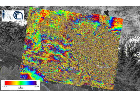
The figure shows the obtained interferogram, ie the map of the surface deformation induced by the earthquake, which is in a time interval ranging from April 17 to April 29, 2015. Each color band (fringe) indicates a ground shift of approximately 3 cm, with a maximum deformation of about 1 m. The displacement occurred as a result of the earthquake and subsequent shocks. It is the surface response to the fault plane displacement in depth.
The activity has been conducted as part of the agreement between IREA-CNR and the Civil Protection Department (DPC), and in the framework of the TEP-Quick Win project (ESA) and I-AMICA High Technological Infrastructure for Integrated Monitoring of Climate and Environment project, which is funded by MIUR under the National Operative Programme (PON).
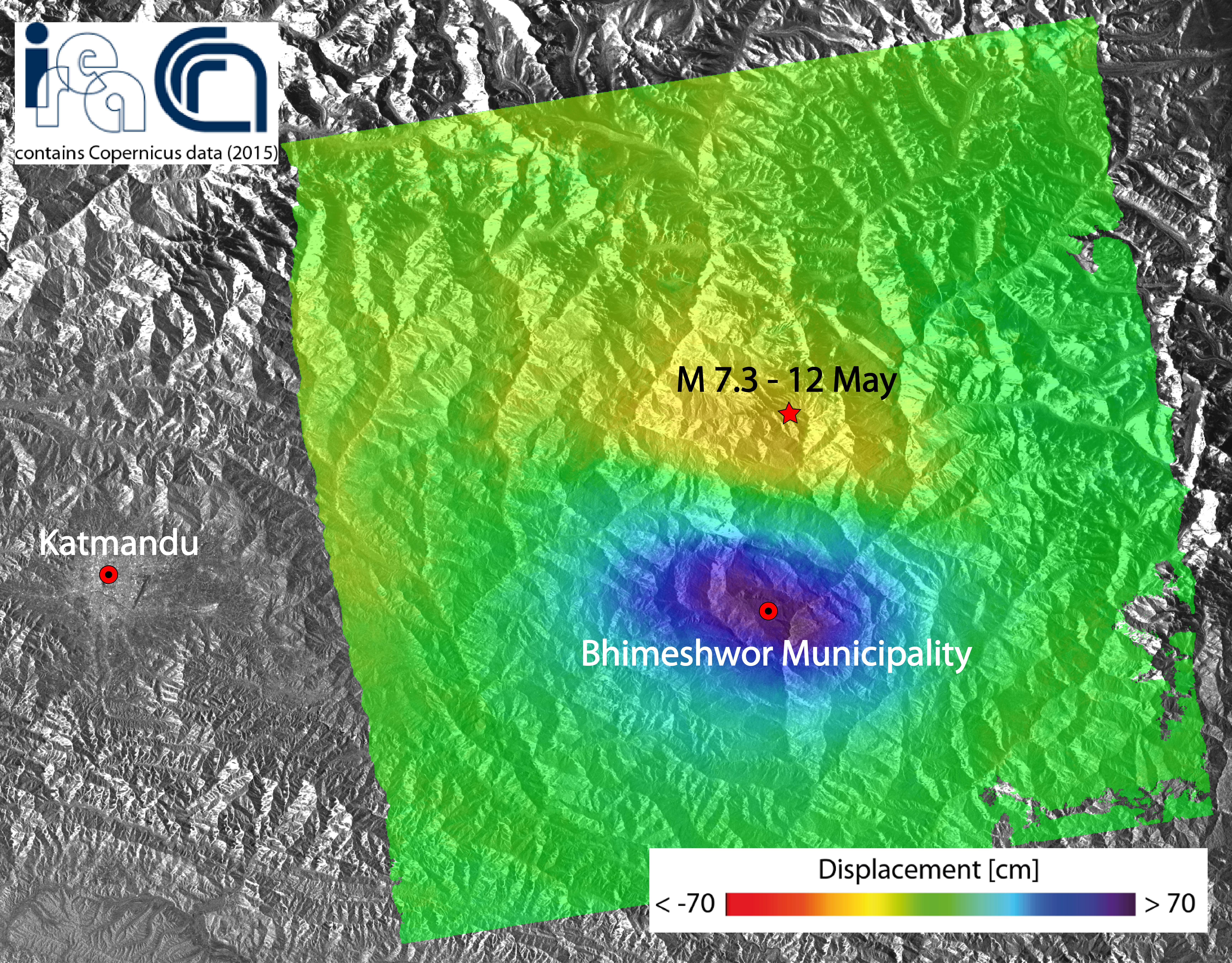
The earthquake of magnitude 7.3 struck the Nepal area on 12 May 2015 and it is the one that, among all the aftershocks, released the biggest energy after the main event of the last April 25th.
Researchers at the Institute for the Electromagnetic Sensing of the Environment of the Italian National Research Council generated a map of the ground displacement induced by this new earthquake through the Differential SAR interferometry technique, by exploiting data acquired by the
The measured displacement field has been very likely induced by the same structures involved in the main shock of the last April 25th, and it is compatible with the migration towards East of the aftershocks.The deformed area extends for about 40 x 60 km2 Eastward of Katmandu. The detected displacement is of about 70 cm toward the satellite in the maximum deforming area (blue zone in the figure). Sentinel-1A satellite of the European program Copernicus.
The activity has been conducted as part of the agreement between IREA-CNR and the Civil Protection Department (DPC), and in the framework of the Geohazards Exploitation Platform (GEP) project (ESA) and I-AMICA (High Technological Infrastructure for Integrated Monitoring of Climate and Environment) project, which is funded by MIUR under the National Operative Programme (PON).
For more detail:
