Region: CALABRIA
Location: Lat: 40°3N, Long: 16°1E, 50 m asl
Description of measurement site
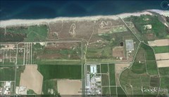
Lamezia Terme’s CNR-ISAC station is located in a strategic and isolated position, 600 m from the coastline of the Lamezia Terme plane, outside the only valley in Calabria which allows the Tyrrhenian Sea to connect with the Ionio Sea.
Its complex orography and its long and narrow shape create a complex interaction of breezes which develop perpendicularly the two coasts with the synoptic circulation, that mainly goes west. In detail, breezes from the sea go mainly W-WSW, while breezes from the earth go mainly E-ENE. Breezes are characterized by seasonal cycles modulated by the temperature gradient between sea and land in addition to the synoptic circulation (more prevalent in determining local circulation in late fall and winter). In particular, while during the summer, è there are strong breezes from the sea during the day, in winter there are, at night, intense breezes coming from the land. It was also demonstrated how the breeze system dominated atmospheric circulation in Lamezia Terme and it has an important role in defining local climates.
The area presents polluting emissions coming from transportation, (airport, cruises from/to Gioia Tauro, local and highway traffic), houses and agriculture in addition to the deposits of a natural particulate like Saharan sand, and volcanic particulate coming from the two active volcanoes in the Mediterranean (Stromboli and Etna situated 80 km west and around 200 km south-east of the measurement site respectively). Studying atmospheric circulation becomes particularly relevant in order to characterize variability of atmospheric composition, for researches regarding renewable (solar and wind) energy and for the coast characterization to prevent fires and erosion.
Main Scientific Results:
The main scientific results obtained in the last years by the Lamezia Terme site, encompass the study of variability of atmospheric circulation with reference to the study of coast breezes (Federico et al., 2010a, b; Lo Feudo et al., 2010), development of vertical structure of the coastal planetary boundary layer and wind profiles in different atmospheric regimes (Wagner et al., 2010).
Referencesi:
Federico S., Pasqualoni L., Semprevi-va A. M., De Leo, L., Avolio E., Calidonna, C. R., and Bellecci, C.: The seasonal characteristics of the breeze circulation at a coastal Mediterranean site in South Italy, Adv. Sci. Res., 4, 47-56, doi:10.5194/asr-4-47-2010, 2010a.
Federico, S., Pasqualoni, L., De Leo, L., Bellecci, C.: A study of the breeze circulation during summer and fall 2008 in Calabria, Italy, Atmospheric Research, 97, 1–2, 1-13, 2010b.
Lo Feudo T., C. Calidonna, A. M. Sempreviva, M. Courtney, L. De Leo, S. Federico, R. Wagner, and C. Bellecci: Flow evolution at a coastal site in the Central Mediterranean, Proceeding ISARS 2010.
Wagner R., C. Calidonna, M. Courtney, Lo Feudo, L. De Leo, A. M. Sempreviva: 2010 Use of Doppler LIDAR for measuring the vertical profiles of wind speed at a coastal site Poster. ISARS 2010, International Symposium for the Advancement of Boundary Layer Remote Sensing, Paris, France, 28-30 June 2010.


