


Sistema di Elaborazione ed Archiviazione Dati Telerilevati
j F Y in Senza categoria
Vista in 3D della componente verticale degli spostamenti del suolo associati all’evento sismico che ha colpito l’Isola di Ischia il 21 agosto 2017, stimata a partire dai dati SAR acquisisti dalle costellazioni Sentinel-1 e COSMO-SkyMed.
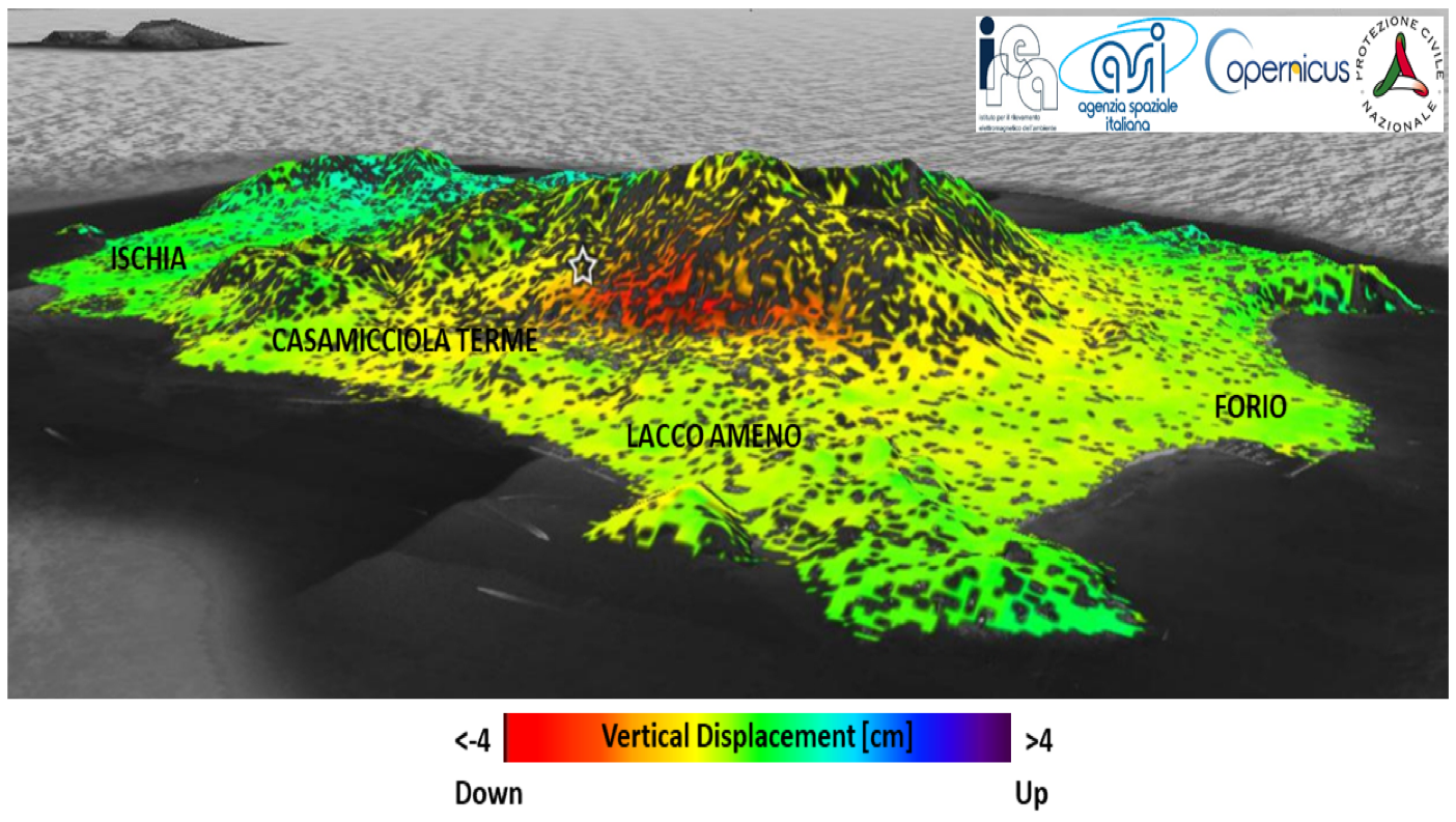
La stella bianca indica la posizione dell’epicentro dell’evento sismico (fonte INGV). Tale mappa rivela un abbassamento del suolo fino a un massimo di 4 cm in un’area (rappresentata in colore rosso) a ridosso di Casamicciola Terme, la più colpita dai crolli.
_____________________________________________________
Per informazioni:
Istituto IREA – Istituto per il Rilevamento Elettromagnetico dell’Ambiente
via Diocleziano 328, 80124, Napoli
Mariarosaria Manzo, Antonio Pauciullo
E-mail manzo.mr@irea.cnr.it, pauciullo.a@irea.cnr.it
Pubblicazioni scientifiche
Cheloni, D., et al. (2017) “Geodetic model of the 2016 Central Italy earthquake sequence inferred from InSAR and GPS data”, Geophys. Res. Lett., 44, 6778–6787, doi: 10.1002/2017GL073580.
De Luca, C., Zinno, I., Manunta, M., Lanari, R., Casu, F. (2017) “Large areas surface deformation analysis through a cloud computing P-SBAS approach for massive processing of DInSAR time series”, Remote Sensing of Environment, 202, 3-17, doi: 10.1016/j.rse.2017.03.022.
De Novellis, V., et al. (2018) “The 21 August 2017 Ischia (Italy) Earthquake Source Model Inferred From Seismological, GPS, and DInSAR Measurements”, Geophys. Res. Lett., 45, 2193-2202, doi:10.1002/2017GL076336.
Pauciullo, A., Reale, ,D., Franzé, W., Fornaro, G. (2018) “Multi-Look in GLRT-Based Detection of Single and Double Persistent Scatterers,” IEEE Transactions on Geoscience and Remote Sensing, vol. 56, no. 9, pp. 5125-5137, doi: 10.1109/TGRS.2018.2809538.
Pepe, A., Calò, F. (2018) “A Review of Interferometric Synthetic Aperture RADAR (InSAR) Multi-Track Approaches for the Retrieval of Earth’s Surface Displacements”, Applied Sciences Appl. Sci. 2017, 7, 1264, doi:10.3390/app7121264.
Pepe, A., Impagnatiello, F., Imperatore, P., Lanari, R. (2018) “Hybrid Stripmap/ScanSAR Interferometry: Extension to the X-Band COSMO-SkyMed Data”, IEEE Geoscience and Remote Sensing Letters, vol. 15, n.3.
Verde, S., Reale, D., Pauciullo, A., Fornaro, G. (2018) “Improved Small Baseline processing by means of CAESAR eigen-interferograms decomposition”, ISPRS Journal of Photogrammetry and Remote Sensing, vol. 139, pp. 1-13.
Yu, l., Yang, T., Zhao, Q., Liu, M., Pepe, A., (2017), “The 2015-2016 Ground Displacements of the Shanghai Coastal Area Inferred from a Combined COSMO-SkyMed/Sentinel-1 InSAR Analysis, Remote Sens., vol. 9, 1194, doi:10.3390/rs9111194.
Zinno, I., Bonano, M., Buonanno, S., Casu, F., De Luca, C., Manunta, M., Manzo, M., Lanari, R. (2018). National Scale Surface Deformation Time Series Generation through Advanced DInSAR Processing of Sentinel-1 Data within A Cloud Computing Environment. IEEE Trans. Big Data, doi:10.1109/TBDATA.2018.2863558.
Capitoli di libro
Bonano, M., Manzo, M., Casu, F., Manunta, M., Lanari, R. (2017). DInSAR for the Monitoring of Cultural Heritage Sites. In: Masini N., Soldovieri F. (eds) Sensing the Past. Geotechnologies and the Environment, vol. 16. Springer, Cham. doi: 10.1007/978-3-319-50518-3_6.
Partecipazione a convegni
Zinno I., Bonano M., Buonanno S., Casu F., De Luca C., Fusco A., Lanari R., Manunta M., Manzo M., Pepe, A. (2017), Sentinel-1 Data Exploitation For Automatic Surface Deformation Time-Series Generation Through The Sbas-DInSAR Parallel Processing Chain, IGARSS 2017, Fort Worth (Texas, USA), 23-28 July 2017.
De Novellis et al. (2017), Source investigation of the 21st August 2017 Ischia Island (Italy) earthquake through the joint analysis of DInSAR, GPS and seismological measurements, GNGTS 2017, Trieste (Italy), 14-16 November 2017.
Casu, F., M. Bonano, C. De Luca, R. Lanari, M. Manunta, M. Manzo, I. Zinno (2018), National Scale Surface Displacements Mapped via the P-SBAS DInSAR Processing of Sentinel-1 Data, EUSAR 2018, Aachen (Germany), 4-7 June 2018.
Zinno, I., M. Bonano, S. Buonanno, F. Casu, C. De Luca, R. Lanari, M. Manunta, M. Manzo,G. Zeni (2018), Surface deformation mapping of Italy through the P-SBAS DiNSAR processing of Sentinel-1 data in a cloud computing environment, 2018 IEEE International Geoscience and Remote Sensing Symposium, Valencia (Spain), July 22-27 2018.
